
Adoption backs this up. North American commercial fleets had 19.2 million active fleet-management systems running in Q4 2024, and that number is projected to hit 33.2 million by 2029, according to Berg Insight's fleet management report.
Here's the problem: plenty of businesses buy cellular trackers without understanding how the technology actually functions. That gap leads to the wrong device, coverage blind spots, and expectations that don't match reality. This guide breaks down exactly how cellular asset tracking works, stage by stage.
Key Takeaways
- Pairs a GPS/GNSS chip with a cellular modem to transmit location data over mobile networks.
- Runs through four stages: initiation, data capture, transmission, and dashboard output.
- Costs less than satellite tracking but needs cell coverage, unlike short-range Bluetooth.
- Powers real-time tracking for fleet vehicles, construction equipment, and cold chain logistics.
What Is Cellular Asset Tracking?
Cellular asset tracking uses a small hardware device attached to a vehicle or piece of equipment. That device pulls its position from GPS/GNSS satellites, then uses a 4G/LTE cellular modem to send that location and status data to a cloud-based platform, typically in near real-time.
It replaces the old way of doing things: manual check-ins, spreadsheet logs, and periodic physical audits. Instead, you get continuous, automated visibility without anyone lifting a clipboard.
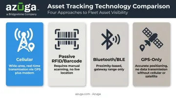
Cellular tracking is often confused with other methods. Here's what sets it apart from three common alternatives
- Passive RFID/barcode tracking: requires someone to manually scan a tag; no independent location broadcast
- Bluetooth/BLE tracking: only works within range of a nearby gateway or reader, making it a proximity tool rather than a wide-area one
- GPS-only trackers: pinpoint location accurately but can't transmit that data anywhere without a cellular or satellite connection
Cellular remains the go-to choice for mobile, long-range assets because cellular network coverage is close to universal across populated and road-based areas. That's a hard advantage over satellite systems, which still cost more for most fleet use cases.
Not every cellular tracker looks the same, either. You'll typically see
- Hardwired devices: mounted to powered equipment and typically installed for rugged or theft-prone assets
- Battery-powered, non-powered asset trackers: used on trailers, tools, and heavy equipment without a power source; Azuga's CalAmp TTU and Queclink GL series units run anywhere from 6 months to 5 years on a single charge, depending on the model and usage
- Bluetooth beacons: low-power tags for tools and containers that pair with a nearby gateway tracker
Installation method and reporting frequency both shift depending on which type you deploy.
How Does Cellular Asset Tracking Work?
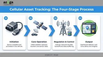
Cellular asset tracking moves through a defined sequence: initiation, core operation, regulation/control, and output. Each stage builds on the last to deliver real-time visibility.
Initiation
Everything starts with installation and activation. Depending on the device type, this looks different
- Hardwired units — wired into powered equipment by a technician or field tech
- Battery-powered/magnetic mount — attached to non-powered assets like trailers or generators, activating once powered on
- Bluetooth beacons — paired with a gateway tracker for tools, containers, and small equipment
From there, the device reports either continuously or on a set interval. This choice matters more than most buyers realize, since it directly trades off battery life against data granularity.
Azuga structures this by plan tier rather than leaving it fully open-ended
| Plan | Reporting Frequency |
|---|---|
| BasicFleet | Every 2 minutes |
| SafeFleet | Every 1 minute |
| CompleteFleet | Every 30 seconds |
A 30-second interval gives you near real-time visibility, which matters a lot if you're trying to catch a theft in progress or verify a technician's arrival time down to the minute.
Core Operation
At the center of the whole system is a GNSS receiver calculating position using satellite signals. The process relies on multiple satellites working together, not just one.
GPS satellites transmit timed radio signals, and a receiver measures the travel time from at least four satellites to fix a precise 3D position and correct its own clock, according to NOAA's explanation of the Global Positioning System.
Once the device has a position, its built-in cellular modem packages that data with whatever sensor readings the hardware supports. On Azuga's platform, that typically includes
- Speed, hard braking, and sudden acceleration
- Idle time and trip distance
- Fuel level and odometer mileage
- Geofence entry/exit and dwell time
This packaged data then queues for transmission. Location accuracy, refresh rate, and how often data is captured versus how often it's actually sent are the performance variables that separate a decent tracker from a mediocre one.
Regulation / Control
As an asset moves, the device has to hand off between cell towers and sometimes between carrier networks entirely. This handoff has to happen without dropping data, which is trickier than it sounds when a truck crosses into a rural area with sparse coverage.
Two fallback mechanisms keep things running
- Cell tower triangulation — steps in when GPS/satellite signal is weak, estimating position from nearby towers instead. Accuracy here is rougher, ranging from kilometer-level with single-tower estimates down to a few hundred meters with multi-tower methods.
- Data buffering (store-and-forward) — when a device loses cellular coverage entirely, it stores timestamped records locally and uploads them once connectivity returns.
This stage matters because it's the difference between a system with data gaps and one that gives you a complete, secure record — encrypted in transit, with no blind spots in remote or indoor areas.
Output / Result
Everything captured and transmitted lands on a dashboard or mobile app as real-time location, status, and behavioral data. From there, it feeds directly into fleet workflows: geofence alerts, maintenance reminders, utilization reports, and driver safety scoring.
The value goes well beyond mapping. A 2024 Verizon survey of over 2,500 fleet professionals found that GPS/fleet-tracking users reported average reductions of 7% in fuel costs, 9% in labor costs, and 14% in accident costs, according to Verizon Connect's 2024 Fleet Technology Trends Report.
Azuga customers report similar patterns internally: an average of $9,462 in annual savings, a 38% drop in accidents, and a 57% reduction in speeding citations.
On Azuga's platform, this output also connects to SafetyCam AI dashcam footage. When a hard-braking event triggers a video clip, that clip shows up alongside the vehicle's exact map location, speed, and timestamp in the same dashboard view.
Where Cellular Asset Tracking Is Used
Cellular tracking fits best wherever assets move across wide areas rather than staying inside one building. Common deployments include
- Fleet vehicles: delivery trucks, service vans, sales fleets
- Construction and heavy equipment: excavators, generators, trailers left on job sites overnight
- Trailers and containers: tracked independently of the towing vehicle
- Service fleets tools: for utilities, waste management, and telecom crews working across scattered locations
It performs best outdoors, across long-distance routes, and in regions with solid carrier coverage. Indoor warehouses or single-building operations usually get more value from BLE instead.
Beyond location and carrier coverage, industry-specific needs also shape how cellular trackers get configured. Cold chain and food transport operations often pair cellular trackers with temperature sensors to monitor in-transit conditions, not just location. Construction fleets, meanwhile, tend to prioritize geofencing and anti-theft alerts, since equipment left overnight on remote sites is a common theft target.
Azuga's Asset Management tools, for instance, are built to protect vehicles, trailers, and high-value equipment on a single platform, with alerts flagging issues as they happen.
Cellular vs. Other Asset Tracking Technologies
People mix up GPS and IoT constantly, so let's clear that up first. GPS is a positioning technology — it tells you where something is. IoT is the broader ecosystem of connected sensors, networks, and platforms that use GPS data (plus other inputs) to enable automation and smart alerts. GPS answers "where." IoT answers "what should happen next."
Now, how does cellular actually stack up against the alternatives?
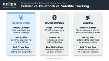
| Technology | Range/Coverage | Battery Life | Best-Fit Use Case |
|---|---|---|---|
| Cellular GNSS | Wide-area, wherever carrier coverage exists | Reporting frequency drives battery life; some rugged units last up to 10 years | Vehicles, trailers, equipment needing recurring remote updates |
| Bluetooth/BLE | Gateway-bounded, local only (roughly 500 sq. meters per gateway setup) | Up to 3 years on a coin battery at low broadcast rates | Indoor tools, yards, facilities with installed gateways |
| Satellite | Global, works beyond cell coverage | Device-dependent, often solar-assisted | Remote corridors, mining, wilderness operations |
Azuga's own cellular trackers report every 30 seconds by default, prioritizing real-time visibility over the multi-year battery life you'd get from a low-power BLE tag. Many modern trackers now combine technologies, defaulting to cellular where coverage exists and falling back to satellite when it doesn't. This hybrid approach ensures continuous reporting regardless of where an asset travels, though it typically comes at a higher hardware cost than a cellular-only device.
Conclusion
Cellular asset tracking follows a coordinated cycle. GPS pinpoints the vehicle's location, then a cellular modem sends that data across the network, which manages tower handoffs and coverage gaps automatically. A dashboard turns that raw feed into insights you can act on.
Understanding each stage makes hardware selection, coverage planning, and platform evaluation a lot less guesswork-driven. That matters because your fleet management platform is only as reliable as the connectivity it's built on, whether you're evaluating Azuga's GPS trackers or any other cellular-based system.
Frequently Asked Questions
How does cellular tracking work?
A device uses GPS to determine its location. A built-in cellular modem then transmits that data over mobile networks to a cloud dashboard, usually within seconds to a few minutes depending on the reporting interval.
What is the difference between GPS and IoT?
GPS is a positioning technology that calculates location using satellite signals. IoT is the broader network of connected devices and platforms that use GPS data alongside other sensor inputs for automation and insights.
What is the difference between cellular and satellite asset trackers?
Cellular trackers rely on mobile networks, making them ideal for populated or road-based areas. Satellite trackers work globally, even without cell coverage, but they typically cost more to deploy and operate.
How accurate is cellular asset tracking?
GPS-enabled devices are typically accurate within about 4.9 meters (16 feet) under open-sky conditions, according to GPS.gov's accuracy data. Buildings, bridges, and dense tree cover can reduce that precision.
Does cellular asset tracking work without cell service?
Most devices buffer and store location data locally, then transmit it once cellular coverage resumes. Some hybrid devices use satellite connectivity as a backup for continuous reporting in dead zones.
How much does a cellular asset tracker cost?
Hardware ranges from basic plug-and-play devices to rugged hardwired units. Monthly service varies per vehicle, depending on reporting frequency and features, and Azuga matches packaging to fleet size and the features you select.